

WEATHER
In this article we will be having a look at weather forecasting, along with short term forecasting out on the ground using cloud formations and wind directions.
The two best weather forecasting resources in our opinion are;
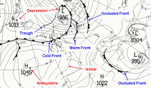
Isobars – are lines on a weather map joining together places of equal atmospheric pressure. At sea level the average hPa (Hectopascals) is 1013. Everything over this number is a High pressure, and everything below is a Low pressure. On the map the isobar marked 1022 represents an area of high pressure, while the isobar marked 995 represents an area of low pressure. In areas of high pressure we would expect to observe fairly clear skies. In areas of low pressure the air condenses to form clouds, and skies are usually overcast.
Anti-Cyclonic – High pressure Isobars rotate clock-wise, thus where an isobar of high pressure meets your position on the map, the wind direction will be running in line with the isobar. In this example the wind direction in Northern Ireland will be coming from the NW. Note In the southern hemisphere the direction of is the opposite i.e winds are carried round a high in an anti-clockwise direction.
Cyclonic – Low pressure bars rotate anti-clockwise. In the above example the wind direction in Britain will be coming from the SE.
Cold fronts – are usually associated with depressions. A cold front is the transition zone where a cold air mass is replacing the warmer air mass. The cold air is following the warm air and gradually moves underneath the warmer air. When the warm air is pushed upwards it will rain heavily. More rain will often fall in the few minutes the cold front passes than it will during the whole passage of a warm front. As the cold front passes, the clouds roll by and the air temperature is cooler.
Cold fronts are shown on synoptic charts by a solid line with triangles along the front pointing towards the warmer air and in the direction of movement. On coloured weather maps, a cold front is drawn with a solid blue line with blue triangles.
Warm fronts– are formed when warm air rises over a mass of cold air. As the air lifts into regions of lower pressure, it expands, cools and condenses the water vapour as wide, flat sheets of cloud.
Warm fronts are shown on synoptic charts by a solid line with semicircles pointing towards the colder air and in the direction of movement. On coloured weather maps, a warm front is drawn with a solid red line with red semicircles.
Occluded fronts – occur at the point where a cold front takes over a warm front or the other way around. If a cold front undercuts a warm front it is known as a cold occlusion and if the cold front rises over the warm front it is called a warm occlusion. Occluded fronts bring changeable weather conditions.
On a synoptic chart, occluded fronts are represented by semicircles and triangles positioned next to each other. The triangles are in blue and the semicircles are in red, or both are purple (mixing both red and blue colours together).
Depressions– are areas of low atmospheric pressure which produce cloudy, rainy and windy weather. These low-pressure systems often begin in the Atlantic, moving eastwards towards the UK. They are responsible for the UK’s changeable weather.
Anticyclones – are the opposite of depressions – they are an area of high atmospheric pressure where the air is sinking.
Trough- A trough on a weather map is an elongated area of relatively low pressure. Troughs bring cloudy and rainy weather and are represented by a hash mark.
CLOUDS
Clouds can also help you to read approaching weather, there are 4 types of clouds, high clouds, medium clouds, low clouds and clouds with vertical growth. and within these four types are 3 main shapes;
Cumulus – Greek for a heap or pile
Stratus – Greek for long sheet or layer
Nimbus – Rain like
High clouds 16-50,000 ft
Fair weather clouds are white and high in the sky it should be noted that these clouds rarely block sunlight. High clouds include;
Cirrus– is made from ice crystals as the cloud forms at temperatures well below freezing. Cirrus is greek for “hair-like” and shows that the weather will be fair.
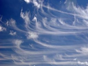
Cirrus
Cirrostratus – Appears as a hazy sheet. Precipitation is likely to occur within 24 hours
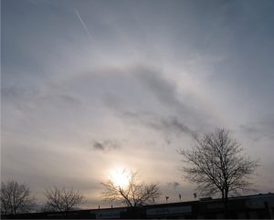
Cirrostratus
Cirrocumulus – Neatly aligned small clouds or Mackerel sky. Fair weather.

Medium clouds – 6.5-16,000 ft
Thick layers of medium-layer clouds give heavy persistent rain, especially if the clouds are dark and grey.
This includes;
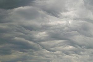
Altocumulus– they signify fairly deep instability.

Altocumulus
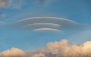
Lenticular – Lenticular clouds are formed by high winds, and typically align with the direction of the wind.
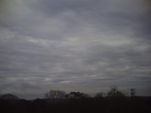
Altostratus– Grey/Blue clouds, covering most of the sky. usually indicates the approach of a warm front.
Altostratus
Low clouds – Below 6500 ft
Low clouds can indicate whether rain will fall in short down pours or persistently.
Stratus– dense grey cloud that covers the sky in a sheet, rain can fall continuously and for long periods of time.
Nimbostratus– can cause moderate to heavy persistent rain.

Nimbostratus
Stratocumulus– covers the sky in an irregular sheet that can be either grey or white in colour. These can lead to drizzle or snow.
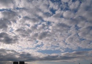
Stratocumulus
Clouds with vertical growth
Cumulonimbus
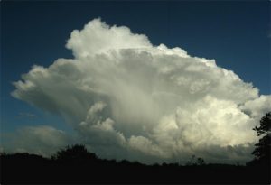
High cloud . Cumulonimbus
Cumulonimbus is associated with thunderstorms and heavy rain. Anvil shaped at the top, the anvil points into the direction of the wind/front
Never underestimate the weather and ensure that you make it a priority that you check the forecast before you leave for your trip. Cumulus– often develops on bright sunny days in slightly unstable air masses. As long as these billowing, puffy clouds keep their form, they, along with blue sky, indicate fine weather.
Wind Direction
As discussed above, reading the isobars on the Synoptic can give you the wind direction, but which weather systems will be brought in in the UK by differing wind directions?
Northerly winds
Also known as a Arctic Maritime, given the fact that a Northerly brings cold air from the Arctic and travels over the North sea. Northerly’s tend to bring cold, precipitous (wet or snow in winter) weather.
North Westerly
Also know as a Polar maritime coming from Greenland/Arctic sea. NW winds will bring cold showery weather.
Westerly
Also know as a Returning Polar Maritime. Winds coming from the east will bring unstable weather systems. Typical weather to be expected is clear weather which quickly turns rainy, then turning to clear sky’s again.
South West
Also known as Tropical Maritime, tends to bring wet and cloudy mild weather. winds come from the Atlantic ocean.
South East
Also Known as Tropical Continental, winds coming from the SE brings hot, dry air which blows in from N. Africa.
Easterly
Also Known as Polar Continental. during the summer this brings warm dry air from Europe. During the winter Easterly’s will bring snow and cold air from Russia.